-
03
Feb
Heavy snow and ice storm plastering Midwest, mid-South: some states to issue big rig restrictions
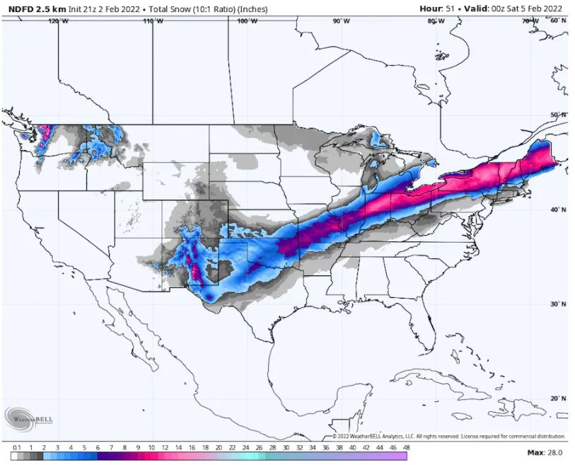
Cities including Dallas, Memphis and Little Rock are likely to experience ice storm conditions and face potential power outages through Thursday, while regions farther north will pick up heavy snow. A light glaze of ice could extend as far southeast as Houston Thursday, which was placed under a winter weather advisory.The storm had already unloaded over a half foot of snow in Denver and Chicago between Tuesday night and Wednesday. At least 6 to 10 inches of new snow is possible across parts of the Midwest, including St. Louis, Indianapolis, Toledo and Detroit through Thursday.
On Wednesday evening, snow, sleet and freezing rain were increasing across northern Texas and Oklahoma as the storm’s second wave, poised to surge east, was taking shape.
The National Weather Service called the storm “large, prolonged, and significant.”
In the interior Northeast, more than 10 inches of snow could fall in Buffalo; Syracuse, N.Y.; and Burlington, Vt., late Thursday into Friday.
A messier stew of sleet, freezing rain, snow and rain is anticipated in eastern New England on Friday, where crashing temperatures may induce a flash freeze that could turn roads into skating rinks.
Meanwhile, flooding is a possibility on the system’s warm side in the Deep South. Thursday will feature isolated severe thunderstorms across southeastern Louisiana, southern Mississippi, southwestern Alabama and the Florida Panhandle, with tornado activity a possibility.
INDIANA TOLLWAY
From 12 a.m. Eastern Standard Time Wednesday, Feb. 2, until 6 p.m. Eastern Standard Time on Thursday, Feb. 3, the following vehicles are not permitted on the Toll Road:
- All Triple tractor-trailers
- All Doubles
- High-profile steel haulers
- High-profile oversize permit loads.
OHIO TURNPIKE
The Ohio Turnpike has issued a travel ban for all high-profile vehicles from Toll Plaza 2 to Toll Plaza 239, effective from 7 a.m. Wednesday, Feb. 2, through 12 p.m. Friday, Feb. 4.
The implemented travel ban will be continually evaluated throughout the duration of the storm.
When a travel ban is placed into effect, the following types of vehicles shall be banned from traveling the Ohio Turnpike until the travel ban is canceled:
- Box-type double-trailer combination commercial vehicles in excess of ninety (90) feet in length.
- Mobile home / Office trailers.
- Boat and horse trailers towed by passenger vehicles or pickup trucks.
- High-profile campers and enclosed trailers, which are defined as trailers designed for a person of average height to stand in.
In response to weather expected Thursday, PennDOT has announced Tier 1 Restrictions on the following roadways:
Tier 1: Empty Tractor Trailers
Effective from 12 p.m. Thursday if conditions warrant
- I-80: OH Line to I-99
- I-86: I-90 to NY Line
- I-90: OH Line to NY Line
- I-79: I-80 to End of I-79
Effective from 6 p.m. Thursday if conditions warrant
- I-79: WV Line to I-80
- I-99: PA Turnpike to I-80
- I-279: PA 28 to I-79
- I-376: I-80 to PA Turnpike
- I-70: WV State Line to MD Line
- I-80: I-99 to NJ Line
- I-579: I-376 to I-279
- I-180: US 15 to I-80
- I-84: I-81 to NY Line
- I-380: I-80 to I-81
- I-81: I-80 to NY Line
Illinois Gov. J.B. Pritzker (D) issued a disaster declaration and activated about 130 members of the state National Guard to help deal with expected blizzard conditions. The state Transportation Department also planned to deploy more than 1,800 trucks and equipment to treat roads and respond to weather emergencies, the state said.
By Wednesday night, the first wave of snow had exited Kansas, St. Louis and Chicago, while snow was lingering in Cleveland and Detroit.
Meanwhile, a second wave of frozen precipitation was organizing from northern Texas to Kansas. Due to mounting accidents, Oklahoma City Police tweeted it was no longer responding to non-injury crashes. “Roads are getting slick, so please slow down if you’re out & about,” it wrote.
In Dallas, rain had changed to freezing rain by around 8 p.m. local time. “Don’t travel unless you absolutely have to,” tweeted the Weather Service in Fort Worth.Snowfall totals through 10 p.m. Wednesday night Central time included:
- 10 to 12 inches around Peoria, Ill.
- 9 to 12 inches around Denver
- 6 to 10 inches around Chicago
- 8 inches around South Bend, Ind.
- 8 inches around Springfield, Ill.
- 6 inches around Wichita
- 4 to 6 inches around Jefferson City and Columbia, Mo.
- 4 inches around Detroit
- 2 to 4 inches around Oklahoma City
- 2 to 4 inches around Kansas City and St. Louis
To the southeast, flood watches blanketed much of northern and central Alabama, northwest Georgia, middle Tennessee and southeast Kentucky, where a heavy rainfall will persist through Thursday. Rain was coming down across most of Alabama, Tennessee and Kentucky, and were predicted to total up to 3 to 5 inches.
To the north of the ice zone, heavy snow will fall in a swath from northeast Oklahoma through Missouri, the northern Ohio Valley and into interior New England. Cities including St. Louis, Indianapolis, Toledo, Cleveland, Syracuse and Rochester, N.Y. and Burlington, Vt. could all wind up with double-digit snowfall totals.
Behind the first round of snow tapering off Wednesday night, a second round will develop into Thursday, displaced slightly to the south from roughly northeast Texas and eastern Oklahoma into northern Ohio, probably staying southeast of Chicago. That second wave will sweep across the interior Northeast on Thursday night into Friday.
There may be pockets along the Interstate 70 corridor of eastern Missouri, central Illinois and northern Indiana that wind up with nearly a foot when all is said and done, as both waves of snow will transit those areas. If Indianapolis receives a foot or more, it will mark the city’s sixth-heaviest snowstorm on record. Bookkeeping there dates back to World War II.
The long-duration event could feature snowfall through very early Friday in northern Ohio, meaning a 36-hour window of inclement weather. Northern New England will see moderate to heavy snows possibly topping a foot on Thursday night and Friday, but precipitation should clear the coast Friday night.
In southern New England, precipitation will begin as rain before transitioning to freezing rain, sleet and snow as temperatures plummet along and behind the front. Any liquid or slush that falls will quickly freeze up late Friday night, making for treacherous travel conditions. Initial rainfall will also preclude effective pretreatment of roadways with salt and other chemicals.
sources: The Trucker, The Washington Post, penndot.gov

- +1-717-626-1107
- sales@pnglc.com